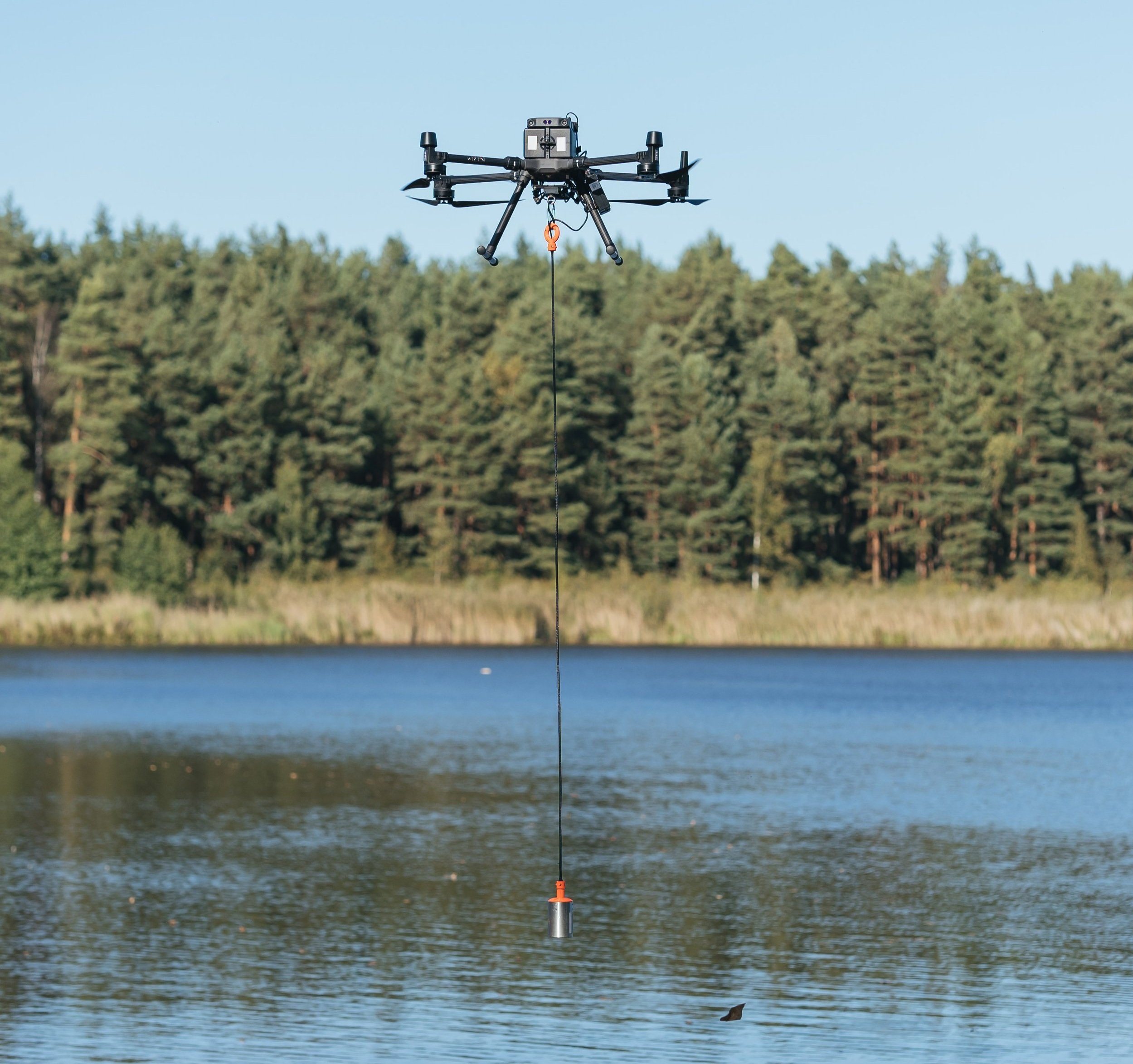
Drone bathymetry using an echosounder is an advanced method for measuring the depth of water bodies and mapping underwater topography. An echosounder emits sound pulses into the water, and by measuring the time it takes for these pulses to bounce back from the seabed or riverbed, it calculates the water depth. When mounted on a drone or an unmanned surface vessel (USV), this technology allows for efficient and detailed mapping of underwater environments.
How Sky Sight Drone Services can carry out bathymetric surveys with drones?
Drone/USV equipped with echosounder: We use drones or small, unmanned surface vessels equipped with echosounders. These devices are connected to GPS and integrated systems to ensure accurate depth measurements.
Survey planning: Using specialised bathymetric survey software, we plan the drone or USV’s navigation path over the target water body, such as rivers, lakes, or coastal areas. This ensures systematic coverage of the entire area.
Data collection: The drone or USV autonomously follows the planned route, sending sonar pulses downward. The echosounder records the time it takes for the sound pulses to return after hitting the bottom surface, calculating the depth based on this time delay.
Post processing and analysis:The depth data is processed and merged with GPS information to create high-resolution bathymetric maps and 3D models of the underwater terrain.
Benefits of drone based bathymetric surveys
Access to shallow or hazardous waters: Traditional boat mounted bathymetric surveys are difficult in shallow or hard to reach areas. Drones and USVs can safely navigate shallow or confined waters that larger vessels cannot access.
High precision: Advanced GPS and echosounder technology allow for highly accurate depth measurements, even in complex underwater environments.
Non disruptive and efficient: Drone bathymetry minimises the need for manned boats, reducing environmental disturbance and the risk to human operators.
Cost effective: By eliminating the need for heavy manned vessels and reducing operational time, drone bathymetric surveys are more cost-efficient than traditional methods.
Real time data collection: Drones can transmit bathymetric data in real time, enabling immediate analysis or decision-making during the survey.
How does it differs from traditional methods?
Mobility and cccess: Traditional bathymetric surveys are often carried out with large, manned vessels, which can be restricted by shallow depths or dangerous water conditions. Drone-based surveys are more versatile and can reach areas that boats cannot.
Speed: Drones and USVs can cover water bodies more quickly and systematically, significantly reducing survey time compared to boats.
Safety: With traditional methods, operators must navigate vessels through potentially hazardous areas. Drone based systems eliminate human risk by allowing for remote operation.
Reduced environmental impact: Since drones and USVs are lightweight and non-intrusive, they create minimal disturbance to the water body, making them ideal for sensitive environments such as marine reserves or wetlands.
At Sky Sight Drone Services, we leverage drone-based echosounder technology to provide efficient, accurate, and safe bathymetric surveys for various applications, such as infrastructure planning, environmental monitoring, and resource management. Our drone bathymetry services offer a faster, safer, and more flexible solution compared to traditional boat based methods.